 Big Bergs Run Aground
As icebergs drift along in the ocean currents, they are like massive ships - without navigators. Sometimes, their meandering path nears the shoreline and they run aground, remaining lodged there until they melt enough to float free, or the tides change.
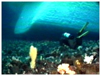
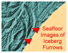
The draft of a berg means how deep the base reaches in the water. That's usually about 1/7 to 1/8 of it, so the part you see on the surface is only a small fraction of what is lurking below the waterline. Seafloor images of shallower areas show deep gouges where the huge masses of ice have ploughed into the seafloor. Given the incredible size of some icebergs, they can be a very powerful "plow", causing considerable destruction and erosion to the ocean floor in the form of deep gouges, scouring and trenches. They literally pulverize everything in their path! Picture: A diver checks out an iceberg run aground.
Click pictures for more information and credits. Library: Arctic, Icebergs, Glaciers Links: Arctic, Icebergs, Glaciers Maps: Source of North Atlantic Icebergs Arctic Maps & Weather Reports |

|
DICTIONARY: Just "double-click" any unlinked word on this page for the definition from Merriam-Webster's Student Electronic Dictionary at Word Central. |

|
ARCTIC LIBRARY & GLOSSARY: Check this section for an index of the rest of the things you really need to know about the Arctic. |

|
ARCTIC MAPS & WEATHER REPORTS: Maps of the Northwest Passage, explorers' routes, iceberg sources, Nunavut, the Arctic by treeline, temperature... |

|
ARCTIC LINKS: Even more information! Links to sites related to the Arctic and "Iceberg: the Story of the Throps and the Squallhoots". |

|
GUIDE TO ARCTIC SUNRISE & SUNSET: How much sunlight or darkness is there in the Arctic on each day of the year? |
to is the property of their respective owners, and Athropolis is not responsible for their content.
