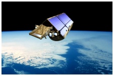
 Eyes in the Sky The Arctic has entered the Space Age! A mission to study the shrinkage of Arctic sea ice is the first objective of the European Space Agency's new Living Planet programme. CryoSat ("cryo" is from the Greek word "kryos", meaning frost or icy cold) is designed to measure changes in the Earth’s terrestrial and marine ice fields. It aims to provide evidence as to whether or not polar ice cover is shrinking as a result of climate change. The satellite's radar will enable it to see, in darkness and in all weather, at least 85% of the ice floating on the surface of the Arctic Ocean. Scientists will be able to use the radar signals which are bounced off the planet's surface to create a 3-D view of the surface sea ice. Although ice floes are typically 2-6 metres / 3-20 feet thick, only 10% of his (20-60 cm / 8-24 inches) can be seen above sea level. CryoSat will measure these differences in height and determine the thickness of the underlying ice. Members of the Franklin Expedition could have used information like that.
Click pictures for more information and credits. Library: Arctic, Glaciers, Ice, Snow Environment/Atmosphere Links: Arctic, Environment Glaciers, Icebergs Arctic Maps & Weather Reports |

|
DICTIONARY: Just "double-click" any unlinked word on this page for the definition from Merriam-Webster's Student Electronic Dictionary at Word Central. |

|
ARCTIC LIBRARY & GLOSSARY: Check this section for an index of the rest of the things you really need to know about the Arctic. |

|
ARCTIC MAPS & WEATHER REPORTS: Maps of the Northwest Passage, explorers' routes, iceberg sources, Nunavut, the Arctic by treeline, temperature... |

|
ARCTIC LINKS: Even more information! Links to sites related to the Arctic and "Iceberg: the Story of the Throps and the Squallhoots". |

|
GUIDE TO ARCTIC SUNRISE & SUNSET: How much sunlight or darkness is there in the Arctic on each day of the year? |
to is the property of their respective owners, and Athropolis is not responsible for their content.