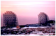
 The Remains of the Cold Cold War A line of old radar stations stretches across the Arctic all the way from northern Alaska, through Canada, and on to Greenland and Iceland. On average, the line is about 200 miles / 320 km north of the Arctic Circle and 1,400 miles / 2250 km from the North Pole. The sixty-three DEW (Distant Early Warning) Line sites were originally set up in the late 1950s by the United States of America. They were built during the "cold war" as a first line of defence to warn of an airborne invasion of North America coming from "over the Pole". Many of the sites were closed down in the early 1960s, and the importance of the DEW Line decreased after tensions between the United States and Russia lessened. The line finally stopped operating in 1993, but it left behind significant damage to the fragile Arctic environment. A cleanup strategy has been developed. The closure does not mean that there is no defensive line. The North Warning System (NWS) in Canada is a new chain of 47 unmanned radar sites that gather information about any activity in the air.
Click pictures for more information and credits. Library: Arctic, Industry/Military Boats/Ships/Submarines Links: Arctic, Environment Arctic Maps & Weather Reports |

|
DICTIONARY: Just "double-click" any unlinked word on this page for the definition from Merriam-Webster's Student Electronic Dictionary at Word Central. |

|
ARCTIC LIBRARY & GLOSSARY: Check this section for an index of the rest of the things you really need to know about the Arctic. |

|
ARCTIC MAPS & WEATHER REPORTS: Maps of the Northwest Passage, explorers' routes, iceberg sources, Nunavut, the Arctic by treeline, temperature... |

|
ARCTIC LINKS: Even more information! Links to sites related to the Arctic and "Iceberg: the Story of the Throps and the Squallhoots". |

|
GUIDE TO ARCTIC SUNRISE & SUNSET: How much sunlight or darkness is there in the Arctic on each day of the year? |
to is the property of their respective owners, and Athropolis is not responsible for their content.