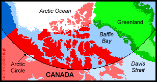
 World's Largest Archipelago The Canadian Arctic covers three Canadian territories: the Yukon, the Northwest Territories and Nunavut. As the Arctic is also defined by temperature and the treeline, it further extends southward along Hudson Bay into northern parts of Manitoba, Ontario, Quebec and Labrador. Covering almost 5000 miles / 8000 km from east to west, the Arctic area stretches from the treeline northward to the world's largest archipelago, with 20 large and many smaller islands.
Canada is one of eight countries with a portion of its land mass within the Arctic Circle. Do you know the others? Play the GAME!
Click pictures for more information and credits. Library: Arctic, Countries/Places Exploration, Links: Arctic, Inuit Northwest Passage Arctic Maps & Weather Reports |

|
DICTIONARY: Just "double-click" any unlinked word on this page for the definition from Merriam-Webster's Student Electronic Dictionary at Word Central. |

|
ARCTIC LIBRARY & GLOSSARY: Check this section for an index of the rest of the things you really need to know about the Arctic. |

|
ARCTIC MAPS & WEATHER REPORTS: Maps of the Northwest Passage, explorers' routes, iceberg sources, Nunavut, the Arctic by treeline, temperature... |

|
ARCTIC LINKS: Even more information! Links to sites related to the Arctic and "Iceberg: the Story of the Throps and the Squallhoots". |

|
GUIDE TO ARCTIC SUNRISE & SUNSET: How much sunlight or darkness is there in the Arctic on each day of the year? |
to is the property of their respective owners, and Athropolis is not responsible for their content.
