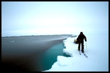
 Take the Lead - But Watch Out For Leads! One might think that with the extremely low temperatures near the North Pole, the ice must be hard, thick and smooth - making travel over the Arctic Ocean quite easy. Not so! The ocean is up to 3 miles / 4.8 km deep in some places, and currents cause constant movement and changes on the surface ice. This movement pulls sections of the ice cap apart, creating open lanes of water called "leads". For anyone travelling across the ice, a stretch of deep open water in -40° temperatures (C or F - take your pick) is a formidable obstacle. Anyone slipping into a lead could drown, or quickly freeze to death. These channels can open suddenly and without warning, so much so that some early Arctic explorers would not sleep in sleeping bags for fear of drowning if a lead opened up while they slept. And there are more obstacles - closer to land, where the land or land-locked ice interferes with the movement of the ice cap, steep mountains of ice called "pressure ridges" rise up to block the way. It's tough going out there!
Click pictures for more information and credits. Library: Arctic, Sky/Seasons , Ice Environment/Atmosphere Links: Arctic, Environment Arctic Currents Arctic Maps & Weather Reports |

|
DICTIONARY: Just "double-click" any unlinked word on this page for the definition from Merriam-Webster's Student Electronic Dictionary at Word Central. |

|
ARCTIC LIBRARY & GLOSSARY: Check this section for an index of the rest of the things you really need to know about the Arctic. |

|
ARCTIC MAPS & WEATHER REPORTS: Maps of the Northwest Passage, explorers' routes, iceberg sources, Nunavut, the Arctic by treeline, temperature... |

|
ARCTIC LINKS: Even more information! Links to sites related to the Arctic and "Iceberg: the Story of the Throps and the Squallhoots". |

|
GUIDE TO ARCTIC SUNRISE & SUNSET: How much sunlight or darkness is there in the Arctic on each day of the year? |
to is the property of their respective owners, and Athropolis is not responsible for their content.