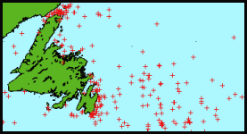
 Collision locations around Newfoundland. Click picture for more. Iceberg Alley "Iceberg Alley" is an area from Baffin Bay (where icebergs enter the water from the massive glaciers on the west coast of Greenland) down to the east coast of Newfoundland and Labrador. That's because there are so many of them, and that's where the bergs enter the shipping lanes. A database of ship collisions with icebergs concentrates on collisions in this North Atlantic area, but also includes a few incidents further north, around Greenland, and in the fiords of Alaska. Now listing over 560 incidents from 1810 to the present, the database focuses on incidents of ships striking icebergs - including the smaller categories of growlers and bergy bits. All attempts are made to make the list as accurate as possible, but sometimes it is unclear whether a "piece of ice" is a small iceberg or an ice floe.
Click pictures for more information and credits. Arctic Library: Ice, Icebergs, Glaciers Boats/Ships, Arctic, Iceberg Source Map Arctic Maps & Weather Reports Links: Arctic, Icebergs Glaciers, Boats & Ships
|

|
DICTIONARY: Just "double-click" any unlinked word on this page for the definition from Merriam-Webster's Student Electronic Dictionary at Word Central. |

|
ARCTIC LIBRARY & GLOSSARY: Check this section for an index of the rest of the things you really need to know about the Arctic. |

|
ARCTIC MAPS & WEATHER REPORTS: Maps of the Northwest Passage, explorers' routes, iceberg sources, Nunavut, the Arctic by treeline, temperature... |

|
ARCTIC LINKS: Even more information! Links to sites related to the Arctic and "Iceberg: the Story of the Throps and the Squallhoots". |

|
GUIDE TO ARCTIC SUNRISE & SUNSET: How much sunlight or darkness is there in the Arctic on each day of the year? |
to is the property of their respective owners, and Athropolis is not responsible for their content.