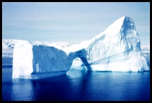
 Let's Take the Measurements Observing icebergs is not only interesting, but necessary. The huge masses of ice create a hazard to ships (remember the "Titanic"?), so they must be identified and reported. This is particularly important in the North Atlantic Ocean, where Arctic bergs drift south into the shipping lanes between Europe and the major ports of the United States and Canada. In this area the cold Labrador Current meets the warm Gulf Stream and the temperature differences of up to 20°C / 68°F produce dense fog. The combination of icebergs, fog, storms, fishing vessels and busy trans-Atlantic shipping lanes makes this area one of the most dangerous for ships. Navigators therefore need all the help they can get, so the International Ice Patrol uses the following size categories to identify icebergs.
Click pictures for more information and credits. Library: Arctic, Icebergs, Glaciers, Ice Links: Arctic, Icebergs, Glaciers International Ice Patrol Maps: Source of North Atlantic Icebergs Arctic Maps & Weather Reports |
|||||||||||||||||||

|
DICTIONARY: Just "double-click" any unlinked word on this page for the definition from Merriam-Webster's Student Electronic Dictionary at Word Central. |

|
ARCTIC LIBRARY & GLOSSARY: Check this section for an index of the rest of the things you really need to know about the Arctic. |

|
ARCTIC MAPS & WEATHER REPORTS: Maps of the Northwest Passage, explorers' routes, iceberg sources, Nunavut, the Arctic by treeline, temperature... |

|
ARCTIC LINKS: Even more information! Links to sites related to the Arctic and "Iceberg: the Story of the Throps and the Squallhoots". |

|
GUIDE TO ARCTIC SUNRISE & SUNSET: How much sunlight or darkness is there in the Arctic on each day of the year? |
to is the property of their respective owners, and Athropolis is not responsible for their content.