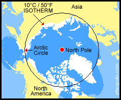
 As well as being the area within the Arctic Circle, the Arctic can also be defined as being the area where the average temperature for the warmest month (July) is below 10°C / 50°F.
An "isotherm" is a line drawn on a weather map or chart linking all points of equal or constant temperature.
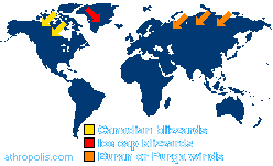
This irregular and shifting July isotherm closely corresponds to the northern limit of tree growth and that varies both above and below the Arctic Circle. As the warmer air at lower latitudes rises, the cold polar air rushes down to take its place. In the extreme cold winter temperatures, these blizzards carry ice crystals that destroy any vegetation that isn't low enough to hide under the snow during the winter months. Just below the surface, the ground in this cold area remains frozen all year long, and the permafrost keeps trees from growing roots long enough to hold them upright.
|

|
DICTIONARY: Just "double-click" any unlinked word on this page for the definition from Merriam-Webster's Student Electronic Dictionary at Word Central. |

|
ARCTIC LIBRARY & GLOSSARY: Check this section for an index of the rest of the things you really need to know about the Arctic. |

|
ARCTIC MAPS & WEATHER REPORTS: Maps of the Northwest Passage, explorers' routes, iceberg sources, Nunavut, the Arctic by treeline, temperature... |

|
ARCTIC LINKS: Even more information! Links to sites related to the Arctic and "Iceberg: the Story of the Throps and the Squallhoots". |

|
GUIDE TO ARCTIC SUNRISE & SUNSET: How much sunlight or darkness is there in the Arctic on each day of the year? |
to is the property of their respective owners, and Athropolis is not responsible for their content.

