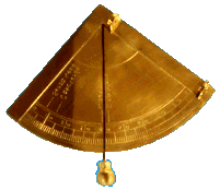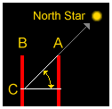
 PICTURE: A mariner's brass quadrant spanning 90°. A plumb bob establishes a vertical line of reference. This one is of the type Columbus might have used to determine latitude on his voyages to the New World. For well over 2,000 years, navigators have known how to determine both direction and latitude (their position north or south of the Equator) by using the North Star (Polaris). When you are facing Polaris you are always facing north, and between the Equator and the North Pole, the angle of the star above the horizon is a direct measure of the degree of latitude. In ancient times, navigators measured the angle of Polaris at their home port (see top picture). To return after a long voyage, they only needed to sail north or south to bring the star back to the angle of home port - then turn left or right and "sail down the latitude," keeping the angle the same all the way.
Click pictures for more information and credits. Library: Sky/Seasons, Exploration, Arctic Links: Constellations, Maps Arctic, Moon Phases Arctic Maps & Weather Reports |

|
DICTIONARY: Just "double-click" any unlinked word on this page for the definition from Merriam-Webster's Student Electronic Dictionary at Word Central. |

|
ARCTIC LIBRARY & GLOSSARY: Check this section for an index of the rest of the things you really need to know about the Arctic. |

|
ARCTIC MAPS & WEATHER REPORTS: Maps of the Northwest Passage, explorers' routes, iceberg sources, Nunavut, the Arctic by treeline, temperature... |

|
ARCTIC LINKS: Even more information! Links to sites related to the Arctic and "Iceberg: the Story of the Throps and the Squallhoots". |

|
GUIDE TO ARCTIC SUNRISE & SUNSET: How much sunlight or darkness is there in the Arctic on each day of the year? |
|
Search for more on this topic...from Athropolis! Select the search engine (up to 4 at one time), enter your request, and click "Search". ( Search Tips ) |
to is the property of their respective owners, and Athropolis is not responsible for their content.
