 Finding Longitude How did early explorers determine their east-west position (degree of "longitude") on the Earth's surface? Latitude (north-south position) was relatively simple, but longitude was a bit of a problem until they came up with a starting point and accurate clocks.
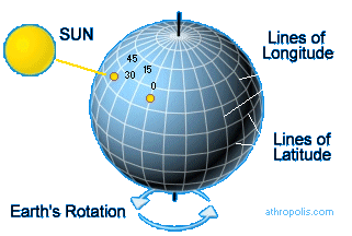
The starting point was established as the "prime meridian" or 0° longitude. This line, along with the opposite meridian at 180° longitude* forms a great circle that divides the Earth into the Eastern and Western Hemispheres.
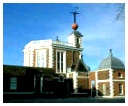
It runs through Greenwich, England, the site of the Royal Observatory (below right) - which is where the people happened to be who came up with this great idea. "We'll start here!"
The Earth spins around (west to east) at a very even pace - every hour it moves 15°. Using the sun as a marker, you can use this rotation to calculate your position in relation to that starting point at 0°. So... if the sun is above the longitude of 0° (the prime meridian) at its highest point (noon), one hour later it will be above 15° west longitude. This is where you need a chronometer (another name for "very accurate clock"). If the sun is at its highest point and your chronometer (which was set to noon when you were at 0°) says it's 3:00 PM, this means that three hours ago the sun was overhead at 0° longitude. In those three hours, the sun moved 15° each hour for a total of 45° - so you're at 45° west longitude. * 180° longitude is also the International Date Line (IDL) which offsets the date as one travels east or west across it. With diversions to pass around some territories and island groups, it mostly corresponds to the time zone boundary separating +12 and -12 hours Greenwich Mean Time (GMT). Crossing the IDL traveling east results in a day or 24 hours being subtracted, and crossing west results in a day being added.
Click pictures for more information and credits. Library: Sky/Seasons, Explorers, Exploration North Star, The Great Bear Links: Arctic, Constellations, Boats & Ships Arctic Maps & Weather Reports |

|
DICTIONARY: Just "double-click" any unlinked word on this page for the definition from Merriam-Webster's Student Electronic Dictionary at Word Central. |

|
ARCTIC LIBRARY & GLOSSARY: Check this section for an index of the rest of the things you really need to know about the Arctic. |

|
ARCTIC MAPS & WEATHER REPORTS: Maps of the Northwest Passage, explorers' routes, iceberg sources, Nunavut, the Arctic by treeline, temperature... |

|
ARCTIC LINKS: Even more information! Links to sites related to the Arctic and "Iceberg: the Story of the Throps and the Squallhoots". |

|
GUIDE TO ARCTIC SUNRISE & SUNSET: How much sunlight or darkness is there in the Arctic on each day of the year? |
to is the property of their respective owners, and Athropolis is not responsible for their content.
