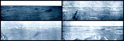
 A View from the Pole For hundreds of years men had tried to reach the North Pole at 90°N latitude. When Robert Peary and his team arrived there in April, 1909, they learned that there was no land there, so they could not claim anything other than having reached a geographical point. Peary photographed four different directions - all looking south - to provide a record that he saw no land. Notice how smooth the ice looks. For about 100 miles / 160 km around the Pole it is very easy to travel because the ocean is so deep there are few of the pressure ridges that are found over shallower regions, or near land.
Click pictures for more information and credits. Library: Ice, Explorers Exploration, Arctic Links: Arctic, Exploration Map Arctic Maps & Weather Reports |

|
DICTIONARY: Just "double-click" any unlinked word on this page for the definition from Merriam-Webster's Student Electronic Dictionary at Word Central. |

|
ARCTIC LIBRARY & GLOSSARY: Check this section for an index of the rest of the things you really need to know about the Arctic. |

|
ARCTIC MAPS & WEATHER REPORTS: Maps of the Northwest Passage, explorers' routes, iceberg sources, Nunavut, the Arctic by treeline, temperature... |

|
ARCTIC LINKS: Even more information! Links to sites related to the Arctic and "Iceberg: the Story of the Throps and the Squallhoots". |

|
GUIDE TO ARCTIC SUNRISE & SUNSET: How much sunlight or darkness is there in the Arctic on each day of the year? |
to is the property of their respective owners, and Athropolis is not responsible for their content.