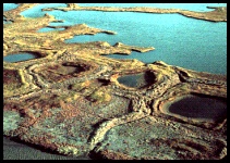
 A Blocky Pattern of Ridges Permafrost soils (soil that remains frozen for at least two years) of the Arctic tundra are covered with an "active layer" - a thin layer of soil that thaws when the summer sun warms the tundra surface. Sometimes ice wedges form "polygons" - a honeycomb of ice walls beneath the soil surface. These can be about 70 feet / 20 meters across, although polygons may be as small as 10 feet / 3 meters across. How does this happen?
Click pictures for more information and credits. Library: Pingos, Thaw Lakes, Wetlands Arctic, Land, Environment/Atmosphere Links: Arctic, Environment Arctic Maps & Weather Reports |

|
DICTIONARY: Just "double-click" any unlinked word on this page for the definition from Merriam-Webster's Student Electronic Dictionary at Word Central. |

|
ARCTIC LIBRARY & GLOSSARY: Check this section for an index of the rest of the things you really need to know about the Arctic. |

|
ARCTIC MAPS & WEATHER REPORTS: Maps of the Northwest Passage, explorers' routes, iceberg sources, Nunavut, the Arctic by treeline, temperature... |

|
ARCTIC LINKS: Even more information! Links to sites related to the Arctic and "Iceberg: the Story of the Throps and the Squallhoots". |

|
GUIDE TO ARCTIC SUNRISE & SUNSET: How much sunlight or darkness is there in the Arctic on each day of the year? |
to is the property of their respective owners, and Athropolis is not responsible for their content.