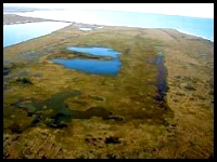
 Thaw Lakes - No Diving, Please Underlying the Arctic plains is a thick, unbroken layer of permafrost. Water that melts on top of the permafrost collects into what are called "thaw lakes". These landforms result from thawing of ice-rich permafrost or the melting of snow and ice, but the frozen ground underneath prevents the water from draining away. Water pools in a depression and its presence begins to further thaw the permafrost underneath and along the lake edges, gradually extending the lake. Most of the thaw lakes along the Arctic Coastal Plain are less than 8 feet / 2½ meters deep, the approximate depth of freezing during the winter, and as a result, they freeze solidly to the bottom, or nearly so.
Click pictures for more information and credits. Library: Pingo, Polygons, Wetlands, Tundra Arctic, Land, Environment Links: Arctic, Environment Arctic Maps & Weather Reports |

|
DICTIONARY: Just "double-click" any unlinked word on this page for the definition from Merriam-Webster's Student Electronic Dictionary at Word Central. |

|
ARCTIC LIBRARY & GLOSSARY: Check this section for an index of the rest of the things you really need to know about the Arctic. |

|
ARCTIC MAPS & WEATHER REPORTS: Maps of the Northwest Passage, explorers' routes, iceberg sources, Nunavut, the Arctic by treeline, temperature... |

|
ARCTIC LINKS: Even more information! Links to sites related to the Arctic and "Iceberg: the Story of the Throps and the Squallhoots". |

|
GUIDE TO ARCTIC SUNRISE & SUNSET: How much sunlight or darkness is there in the Arctic on each day of the year? |
to is the property of their respective owners, and Athropolis is not responsible for their content.