 John Davis: Early Arctic Exploration
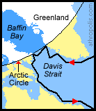
John Davis (1550-1605) was a British scientist, cartographer (map maker), and writer on seamanship who made extensive explorations in the Arctic (Davis Strait is named after him). He is noted for his detailed maps of the coast of Greenland, Baffin Island and Labrador.
Davis was well connected to the explorers, cartographers and scientists of his time. Some of his friends and neighbours were the explorer (Sir) Walter Raleigh and the astronomer and mathematician, John Dee. Like many early explorers, Davis sought the "Northwest Passage", and although he was convinced that a passage existed, he was unsuccessful because of the ice. Nevertheless, he rediscovered Greenland (it had been forgotten after the Norse colonies failed there three centuries before), and he greatly contributed to Europe's knowledge of the Arctic. He drew attention to the sealing and whaling possibilities in Davis Strait and identified cod fisheries in the coastal waters from Labrador to Newfoundland.
Click pictures for more information and credits. Library: Arctic, Explorers Links: Arctic, Northwest Passage Arctic Maps & Weather Reports |

|
DICTIONARY: Just "double-click" any unlinked word on this page for the definition from Merriam-Webster's Student Electronic Dictionary at Word Central. |

|
ARCTIC LIBRARY & GLOSSARY: Check this section for an index of the rest of the things you really need to know about the Arctic. |

|
ARCTIC MAPS & WEATHER REPORTS: Maps of the Northwest Passage, explorers' routes, iceberg sources, Nunavut, the Arctic by treeline, temperature... |

|
ARCTIC LINKS: Even more information! Links to sites related to the Arctic and "Iceberg: the Story of the Throps and the Squallhoots". |

|
GUIDE TO ARCTIC SUNRISE & SUNSET: How much sunlight or darkness is there in the Arctic on each day of the year? |
to is the property of their respective owners, and Athropolis is not responsible for their content.
