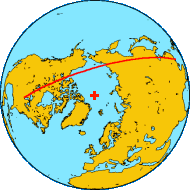
 Shortest Distance Between Two Points Today, many planes fly over the Arctic using "great circle routes" between the continents. The great circle route (picture) between Chicago and Hong Kong passes over the Arctic Ocean and near the North Pole (Marked: + ). A "Great Circle Route" is a trace on the surface of a sphere (the Earth) of a plane that passes through the center of the sphere and divides it into halves. This line indicates the shortest course between two points on the surface of that sphere. The lines of latitude and longitude on a flat map may suggest otherwise, but when you take into consideration that the Earth is round, the best route can be a surprise. Before long-distance air travel, such efficiency was not possible - try sailing over land or through the frozen Arctic Ocean! Imagine picking two points (A and B) on a round melon. When you cut it, the top of your knife will stop at A, the bottom of your knife will stop at B, and the center of your knife will be aligned with the very center of the melon. The cut mark will indicate the shortest distance between A and B on the skin of the melon.
Click pictures for more information and credits. Library: Arctic, Latitude, Longitude Links: Great Circle Mapper Great Circle Route, Arctic Arctic Maps & Weather Reports |

|
DICTIONARY: Just "double-click" any unlinked word on this page for the definition from Merriam-Webster's Student Electronic Dictionary at Word Central. |

|
ARCTIC LIBRARY & GLOSSARY: Check this section for an index of the rest of the things you really need to know about the Arctic. |

|
ARCTIC MAPS & WEATHER REPORTS: Maps of the Northwest Passage, explorers' routes, iceberg sources, Nunavut, the Arctic by treeline, temperature... |

|
ARCTIC LINKS: Even more information! Links to sites related to the Arctic and "Iceberg: the Story of the Throps and the Squallhoots". |

|
GUIDE TO ARCTIC SUNRISE & SUNSET: How much sunlight or darkness is there in the Arctic on each day of the year? |
to is the property of their respective owners, and Athropolis is not responsible for their content.