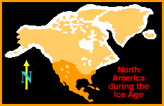
 A Continent Under Ice At the peak of the last glaciation or "Ice Age", most of North America was covered by ice. Present day Canada was covered by ice more than 1000 meters / 3,200 feet thick! Not only did the huge masses of ice scrape, gouge and plow across the continent, but the sheer weight of it pushed coastal areas far below sea level. When the ice melted, the landscape was changed forever. • Without the weight of the ice, the Maine coast of the eastern U.S.A. has risen at least 180 meters / 600 feet. Traces of ice age beaches have been found that far above the present sea level. • Hudson Bay is a depression near the middle of the continent that was the center of ice accumulation. The weight of so much ice left a hole that filled with water. • The Central and Northern Rocky Mountains have U-shaped valleys that were carved by glaciers. Yosemite Valley is a good example - its famous Half Dome is a huge granite rock that was cut in half by the glacier that plowed out the valley.
Click pictures for more information and credits. Library: Land Bridge Arctic, Ice, Glaciers Links: Arctic, Glaciers, Ice Age Arctic Maps & Weather Reports |

|
DICTIONARY: Just "double-click" any unlinked word on this page for the definition from Merriam-Webster's Student Electronic Dictionary at Word Central. |

|
ARCTIC LIBRARY & GLOSSARY: Check this section for an index of the rest of the things you really need to know about the Arctic. |

|
ARCTIC MAPS & WEATHER REPORTS: Maps of the Northwest Passage, explorers' routes, iceberg sources, Nunavut, the Arctic by treeline, temperature... |

|
ARCTIC LINKS: Even more information! Links to sites related to the Arctic and "Iceberg: the Story of the Throps and the Squallhoots". |

|
GUIDE TO ARCTIC SUNRISE & SUNSET: How much sunlight or darkness is there in the Arctic on each day of the year? |
to is the property of their respective owners, and Athropolis is not responsible for their content.