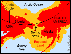
 Land Bridge Links Continents Ocean levels have risen and fallen several times in the Earth's past history. When Ice Ages occur, huge volumes of water are deposited on land in the form of ice and snow. All of that water has to come from somewhere - and this can cause a corresponding drop in sea level. During the last Ice Age (about 15-20,000 years ago) the shallow seas in the area of the Bering Strait dropped about 90 meters / 300 feet and created a 1600 km / 1,000 mile wide grassland steppe, linking Asia and North America. It is believed that it was across this "Bering Land Bridge" that plants and animals traveled in both directions, and humans entered the Americas. This submerged area may still hold archaeological information and provide answers to questions about who the first people were to come to North America, how and when they traveled, and how they survived under such harsh conditions.
Ice Age Links, Library: Ice, Arctic Maps The Last Great Ice Age A Continent Under Ice Continental Ice Sheets Vitus Jonassen Bering Screwing across the Bering Strait |

|
DICTIONARY: Just "double-click" any unlinked word on this page for the definition from Merriam-Webster's Student Electronic Dictionary at Word Central. |

|
ARCTIC LIBRARY & GLOSSARY: Check this section for an index of the rest of the things you really need to know about the Arctic. |

|
ARCTIC MAPS & WEATHER REPORTS: Maps of the Northwest Passage, explorers' routes, iceberg sources, Nunavut, the Arctic by treeline, temperature... |

|
ARCTIC LINKS: Even more information! Links to sites related to the Arctic and "Iceberg: the Story of the Throps and the Squallhoots". |

|
GUIDE TO ARCTIC SUNRISE & SUNSET: How much sunlight or darkness is there in the Arctic on each day of the year? |
|
Search for more on this topic...from Athropolis! Select the search engine (up to 4 at one time), enter your request, and click "Search". ( Search Tips ) |
to is the property of their respective owners, and Athropolis is not responsible for their content.