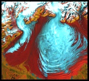
 Malaspina Glacier Flows Over Lowlands At the top of Alaska’s panhandle, Malaspina Glacier spills from a funnel of rock in the St. Elias Mountains and spreads out to form a huge pancake between the mountains and the sea. This massive glacier is the largest "piedmont" glacier on the continent. Piedmont glaciers occur where steep valley glaciers exit a mountain range onto flat plains or lowlands. They are no longer confined, and the ice spreads out in wide bulb-like lobes. Malaspina Glacier is actually a compound glacier, formed by the merger of several valley glaciers. Spilling out of the Seward Ice Field, it covers 1,500 sq. miles / 3,880 sq. km as it spreads across the coastal plain. It is so large that only satellite images can provide a complete overview. Picture: NASA photo of the tongue of the Malaspina Glacier.
|

|
DICTIONARY: Just "double-click" any unlinked word on this page for the definition from Merriam-Webster's Student Electronic Dictionary at Word Central. |

|
ARCTIC LIBRARY & GLOSSARY: Check this section for an index of the rest of the things you really need to know about the Arctic. |

|
ARCTIC MAPS & WEATHER REPORTS: Maps of the Northwest Passage, explorers' routes, iceberg sources, Nunavut, the Arctic by treeline, temperature... |

|
ARCTIC LINKS: Even more information! Links to sites related to the Arctic and "Iceberg: the Story of the Throps and the Squallhoots". |

|
GUIDE TO ARCTIC SUNRISE & SUNSET: How much sunlight or darkness is there in the Arctic on each day of the year? |
|
Search for more on this topic...from Athropolis! Select the search engine (up to 4 at one time), enter your request, and click "Search". ( Search Tips ) |
| AltaVista Google Lycos Yahoo |
to is the property of their respective owners, and Athropolis is not responsible for their content.
