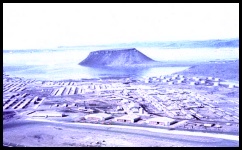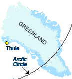
 Ultima Thule In 1910, explorers Knud Rasmussen and Peter Freuchen established an outpost on the northwest coast of Greenland. They called it Thule ("Toolee"). The name is from the "Ultima Thule" of ancient geographers, referring to the farthest north land known to be inhabited by humans. In the early 1900s, the Inuit knew Thule as a trade, medical and social center. Today it is the U.S. Armed Forces' northernmost base which includes a Space Warning Squadron and a Ballistic Missile Early Warning Site designed to detect and track missiles launched against North America.
Thule sits on 1600 feet / 490 meters of permafrost, and as long as everything stays frozen, the buildings sit on solid ground. Ground level buildings have double floors with cold air circulating between them, and other buildings are well above ground to prevent the permafrost from thawing out. If it did, the buildings would be sitting on a slushy mix of water and gravel. What doesn't Thule have? A view of the Northern Lights! The base is almost directly in the center of the "auroral oval" and is too far north to see them.
Click pictures for more information and credits. Library: Arctic, Northern Lights Industry / Military, Inuit, Explorers Links: Arctic, Northern Lights Arctic Maps & Weather Reports Northern Lights Slide Show |

|
DICTIONARY: Just "double-click" any unlinked word on this page for the definition from Merriam-Webster's Student Electronic Dictionary at Word Central. |

|
ARCTIC LIBRARY & GLOSSARY: Check this section for an index of the rest of the things you really need to know about the Arctic. |

|
ARCTIC MAPS & WEATHER REPORTS: Maps of the Northwest Passage, explorers' routes, iceberg sources, Nunavut, the Arctic by treeline, temperature... |

|
ARCTIC LINKS: Even more information! Links to sites related to the Arctic and "Iceberg: the Story of the Throps and the Squallhoots". |

|
GUIDE TO ARCTIC SUNRISE & SUNSET: How much sunlight or darkness is there in the Arctic on each day of the year? |
to is the property of their respective owners, and Athropolis is not responsible for their content.
